 GIS and Media fusion
"The explosive growth of the GeoWeb and geographic information has made GIS powerful media for the general public to communicate, but perhaps more importantly, GIS have also become media for constructive dialogs and interactions about social issues." - Sui & Goodchild
User Tools
This is an old revision of the document!
Table of Contents
Cours GéoInf :: Edition 2017
Bienvenue sur le portail de cours GéoInformation & Open Webmapping
- Enseignants : J. Cela Lopez, O. Ertz, S. Oulevay, D. Rappo
- Salle de cours : HEIG-VD, St-Roch, T155
- Horaire : http://www.comem.ch/horaire
Cours
Plan
Après une première partie découverte de la dimension géospatiale de l'information et conception cartographique (cartographic design) avec QGIS, une suite plus orientée au coeur de la technologie :
- Outil desktop QGIS et son API avec Python
- Base de données SQL géospatiale avec PostGIS
- Services géographiques/cartographiques avec GeoServer/CartoDB
- Interface cartographique avec OpenLayers
- Découvertes :
- NoSQL spatial avec MongoDB
- Géoinformation et réalité augmenté avec Wikitude
![]() Participez : vers une bibliographie partagée sur tous ces sujets …
Participez : vers une bibliographie partagée sur tous ces sujets …
QGIS API & plugins
- Tutoriel (auteure Sarah Composto / HEIG-VD / INSIT) - qgis_plugins.pdf
- ça peut aider :
- si la commande pyrcc4 n'est pas installlée, voici le fichier Python généré - resources.zip (à désarchiver)
- si QtDesigner n'est pas installé, il s'installe avec QtCreator - https://www.qt.io/qt-features-libraries-apis-tools-and-ide/#tools
Spatial database
Mise en place de PostgreSQL/PostGIS avec le service de cloud PaaS Heroku :
- Déployer une app Heroku avec PHP et PostgreSQL - Getting Started on Heroku with PHP https://devcenter.heroku.com/articles/getting-started-with-php#introduction
- Accéder au tableau de bord Heroku Data - https://data.heroku.com
- Choisir une interface PostreSQL
- avec l'application pgAdmin3 - https://www.pgadmin.org/
- avec psql dans un shell interactif (bash) :
- dans le dossier local de votre app heroku, lancer
heroku run bash
- après connexion, à l'invite de commande bash, lancer
psql -U #heroku_dbuser# -h #heroku_dbhost.amazonaws.com# -d #dbname#
- à l'invite de commande psql, saisir une commande
select postgis_version();   # for informations about installed PostGIS
\h # for help with SQL commands
\? # for help with psql commands
- Ajouter l'extension PostGIS à la base - https://devcenter.heroku.com/articles/heroku-postgres-extensions-postgis-full-text-search#postgis
- exécuter simplement la commande SQL ci-dessous
create extension postgis
- voyez l'apparition de nouvelles tables et vues (commande psql \d)
Exercices pratiques :
Avec un “cloud cartographique” :
Geospatial web
A convergence story (Intro slides) - Hacker Cartography: Crowdsourced Geography, OpenStreetMap, and the Hacker Political Imaginary (McConchie 2015)
- Publier des géodonnées avec des services standardisés grâce à GeoServer
- Installation sur Heroku en 20 minutes :
- Télécharger/désarchiver geoserver-2.12.0-war.zip (au choix depuis sourceforge.net, drive.switch.ch)
- Ouvrir une invite de commande dans le dossier contenant le fichier geoserver.war
- Se connecter à heroku, créer une nouvelle app heroku, puis y déployer GeoServer (inspiré de cette documentation)
heroku login
heroku create
heroku plugins:install heroku-cli-deploy
heroku war:deploy geoserver.war --app <appName>
- Naviguer sur votre app et se connecter à GeoServer (admin/geoserver)
- Publier la géotable my4capitals
- Add new workspace: geoinf / http://mediamaps.ch/geoinf
- Stores → Add new store: fournir les credentials d'accès à la BD PostGIS
- (new layer) → Publish: sur my4capitals
- configurer les “bounding boxes”
- Layer Preview: prévisualisation du géoservice (avec le géoservice standardisé OGC WFS - Web Feature Service)
- Ci-dessous les 3 indispensables opérations d'un géoservice de données (utiliser un Query String Splitter pour y voir plus clair)
| WFS:GetCapabilities | service=WFS&version=1.0.0&request=GetCapabilities |
| WFS:DescribeFeatureType | service=WFS&version=1.0.0&request=DescribeFeatureType&typeName=geoinfo:cities |
| WFS:GetFeature | service=WFS&version=1.0.0&request=GetFeature&typeName=geoinfo:cities&maxFeatures=50&outputFormat=application/json |
- En résumé :
- Geoserver est “conçu pour l'interopérabilité, il publie les données de toutes les sources principales de données spatiales utilisant des normes ouvertes” (wikipedia) … de l'OGC (Open Geospatial Consortium)
- What is (not) interoperability? - https://drive.switch.ch/index.php/s/3s1as53UkjJJyn3 (CCG 2017)
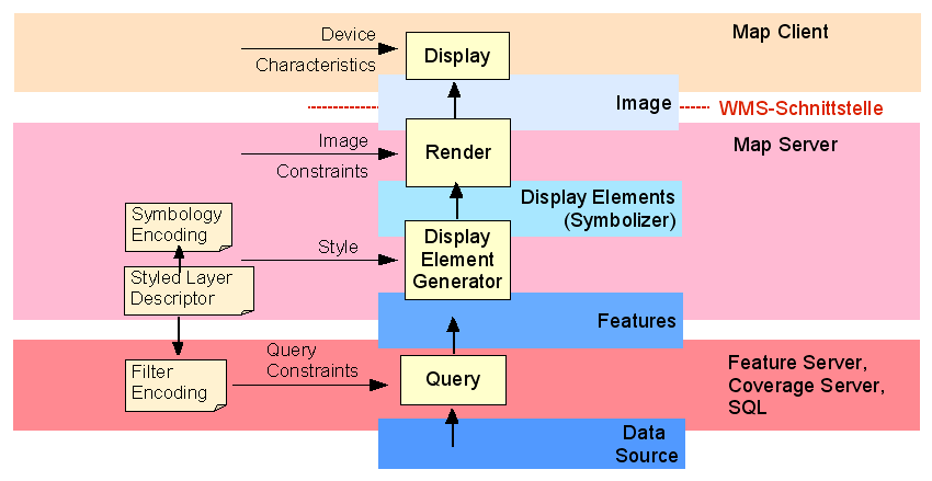
QGIS MapRenderer
- Utilisation du moteur de rendu cartographique QgsMapRenderer et compréhension du “portrayal model” portrayalogc.png
- Vers un langage cartographique commun avec les standards OGC SLD/SE ?
- A redesign of OGC Symbology Encoding standard for sharing cartography - https://peerj.com/preprints/2415/
Open Webmapping
- Des géoservices standardisés pour la cartographie en ligne OGC (Open Geospatial Consortium)
- Ci-dessous les 3 indispensables opérations d'un géoservice de cartographie (utiliser un Query String Splitter pour y voir plus clair)
| WMS:GetCapabilities | service=WMS&version=1.1.0&request=GetCapabilities |
| WMS:GetMap | service=WMS&version=1.1.0&request=GetMap&layers=ne_10m_admin_0_countries&styles=&bbox=-180,-90,180,90&width=800&height=400&srs=EPSG:4326&format=image/png |
| WMS:GetFeatureInfo | service=WMS&version=1.1.0&request=GetFeatureInfo&bbox=-22.5,28.75,22.5,51.25&srs=EPSG:4326&height=400&width=800&layers=ne_10m_admin_0_countries&format=image/png&styles=&query_layers=ne_10m_admin_0_countries&x=517&y=80&feature_count=50&info_format=application/json |
- Sharing cartography: Open standards for cartographic portrayal interoperability
- “Sharing cartography” - les 4 niveaux d'utilisation qui nécessitent une intéropérabilité des représentations cartographiques
- Avec GeoServer … publier la couche world_simple à partir d'une géotable dans la base PostGIS (utiliser ce script SQL - https://drive.switch.ch/index.php/s/23PlCBsdRrgkigd).
- Analyser les paramètres WMS au regard du “portrayal model”
- Simuler “à la main” une navigation cartographique (zoom sur l'Europe, la Suisse au centre, Lat: 47 / Lon: 10)
OpenLayers
- Workshop OpenLayers v3 (part 1) : navigation, composition, style image, couche vector, style vector
- Workshop OpenLayers v3 (part 2) : interrogation de couche et autres interactions
Geospatial AR Lab
- Before we start the lesson (07.12.2017), we ask you to arrive with all the requirements ready:
- follow these instructions (it takes a while)
- test it's ready by running the below instruction in the working directory of your Cordova-based project
cordova platforms ls
The result should look like this:
Available platforms:
  blackberry10 ~3.8.0 (deprecated)
  browser ~5.0.0
  ios ~4.5.1
  osx ~4.0.1
  ubuntu ~4.3.4 (deprecated)
  webos ~3.7.0
  windows ~5.0.0
  www ^3.12.0
Evaluation
- Exercice individuel
- Exercice/projet en binôme
Opportunité CCG
Certificat Complémentaire en Géomatique, University of Geneva - Institute for Environmental Sciences/EnviroSPACE Lab :
- se libérer du 12 au 15 février 2018 → semaine 7 (= interruption de cours)
- s'inscrire comme auditeur libre (droits d'entrée 50CHF)
- recevoir une attestation de suivi du cours (mais pas d'équivalence de crédit)
- un syllabus de la même veine que l'année passée, cf programme 2017
