STYLED LAYER DESCRIPTOR version 1.0.0SLD is an OGC Standard.Copyright (c) 2001,2010 Open Geospatial Consortium.To obtain additional rights of use, visit http://www.opengeospatial.org/legal/ .
LAYERS AND STYLES
FEATURE-TYPE STYLING
SYMBOLIZERS
LINE SYMBOLIZER
POLYGON SYMBOLIZER
POINT SYMBOLIZER
TEXT SYMBOLIZER
RASTER SYMBOLIZER
Properties
attribute form default
unqualified
element form default
qualified
version
1.0.0.2
Element sld:StyledLayerDescriptor
Namespace
http://www.opengis.net/sld
Annotations
A StyledLayerDescriptor is a sequence of styled layers, representedat the first level by NamedLayer and UserLayer elements.
<xsd:element name="StyledLayerDescriptor"><xsd:annotation><xsd:documentation>A StyledLayerDescriptor is a sequence of styled layers, represented at the first level by NamedLayer and UserLayer elements.</xsd:documentation></xsd:annotation><xsd:complexType><xsd:sequence><xsd:element ref="sld:Name" minOccurs="0"/><xsd:element ref="sld:Title" minOccurs="0"/><xsd:element ref="sld:Abstract" minOccurs="0"/><xsd:choice minOccurs="0" maxOccurs="unbounded"><xsd:element ref="sld:NamedLayer"/><xsd:element ref="sld:UserLayer"/></xsd:choice></xsd:sequence><xsd:attribute name="version" type="xsd:string" use="required" fixed="1.0.0"/></xsd:complexType></xsd:element>
<xsd:element name="NamedLayer"><xsd:annotation><xsd:documentation>A NamedLayer is a layer of data that has a name advertised by a WMS.</xsd:documentation></xsd:annotation><xsd:complexType><xsd:sequence><xsd:element ref="sld:Name"/><xsd:element ref="sld:LayerFeatureConstraints" minOccurs="0"/><xsd:choice minOccurs="0" maxOccurs="unbounded"><xsd:element ref="sld:NamedStyle"/><xsd:element ref="sld:UserStyle"/></xsd:choice></xsd:sequence></xsd:complexType></xsd:element>
Element sld:LayerFeatureConstraints
Namespace
http://www.opengis.net/sld
Annotations
LayerFeatureConstraints define what features & feature types arereferenced in a layer.
<xsd:element name="LayerFeatureConstraints"><xsd:annotation><xsd:documentation>LayerFeatureConstraints define what features & feature types are referenced in a layer.</xsd:documentation></xsd:annotation><xsd:complexType><xsd:sequence><xsd:element ref="sld:FeatureTypeConstraint" maxOccurs="unbounded"/></xsd:sequence></xsd:complexType></xsd:element>
Element sld:FeatureTypeConstraint
Namespace
http://www.opengis.net/sld
Annotations
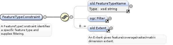
A FeatureTypeConstraint identifies a specific feature type andsupplies fitlering.
<xsd:element name="FeatureTypeConstraint"><xsd:annotation><xsd:documentation>A FeatureTypeConstraint identifies a specific feature type and supplies fitlering.</xsd:documentation></xsd:annotation><xsd:complexType><xsd:sequence><xsd:element ref="sld:FeatureTypeName" minOccurs="0"/><xsd:element ref="ogc:Filter" minOccurs="0"/><xsd:element ref="sld:Extent" minOccurs="0" maxOccurs="unbounded"/></xsd:sequence></xsd:complexType></xsd:element>
<xsd:element name="NamedStyle"><xsd:annotation><xsd:documentation>A NamedStyle is used to refer to a style that has a name in a WMS.</xsd:documentation></xsd:annotation><xsd:complexType><xsd:sequence><xsd:element ref="sld:Name"/></xsd:sequence></xsd:complexType></xsd:element>
Element sld:UserStyle
Namespace
http://www.opengis.net/sld
Annotations
A UserStyle allows user-defined styling and is semanticallyequivalent to a WMS named style.
<xsd:element name="UserStyle"><xsd:annotation><xsd:documentation>A UserStyle allows user-defined styling and is semantically equivalent to a WMS named style.</xsd:documentation></xsd:annotation><xsd:complexType><xsd:sequence><xsd:element ref="sld:Name" minOccurs="0"/><xsd:element ref="sld:Title" minOccurs="0"/><xsd:element ref="sld:Abstract" minOccurs="0"/><xsd:element ref="sld:IsDefault" minOccurs="0"/><xsd:element ref="sld:FeatureTypeStyle" maxOccurs="unbounded"/></xsd:sequence></xsd:complexType></xsd:element>
A FeatureTypeStyle contains styling information specific to onefeature type. This is the SLD level that separates the 'layer'handling from the 'feature' handling.
<xsd:element name="FeatureTypeStyle"><xsd:annotation><xsd:documentation>A FeatureTypeStyle contains styling information specific to one feature type. This is the SLD level that separates the 'layer' handling from the 'feature' handling.</xsd:documentation></xsd:annotation><xsd:complexType><xsd:sequence><xsd:element ref="sld:Name" minOccurs="0"/><xsd:element ref="sld:Title" minOccurs="0"/><xsd:element ref="sld:Abstract" minOccurs="0"/><xsd:element ref="sld:FeatureTypeName" minOccurs="0"/><xsd:element ref="sld:SemanticTypeIdentifier" minOccurs="0" maxOccurs="unbounded"/><xsd:element ref="sld:Rule" maxOccurs="unbounded"/></xsd:sequence></xsd:complexType></xsd:element>
<xsd:element name="Rule"><xsd:annotation><xsd:documentation>A Rule is used to attach property/scale conditions to and group the individual symbolizers used for rendering.</xsd:documentation></xsd:annotation><xsd:complexType><xsd:sequence><xsd:element ref="sld:Name" minOccurs="0"/><xsd:element ref="sld:Title" minOccurs="0"/><xsd:element ref="sld:Abstract" minOccurs="0"/><xsd:element ref="sld:LegendGraphic" minOccurs="0"/><xsd:choice minOccurs="0"><xsd:element ref="ogc:Filter"/><xsd:element ref="sld:ElseFilter"/></xsd:choice><xsd:element ref="sld:MinScaleDenominator" minOccurs="0"/><xsd:element ref="sld:MaxScaleDenominator" minOccurs="0"/><xsd:element ref="sld:Symbolizer" maxOccurs="unbounded"/></xsd:sequence></xsd:complexType></xsd:element>
<xsd:element name="ExternalGraphic"><xsd:annotation><xsd:documentation>An "ExternalGraphic" gives a reference to an external raster or vector graphical object.</xsd:documentation></xsd:annotation><xsd:complexType><xsd:sequence><xsd:element ref="sld:OnlineResource"/><xsd:element ref="sld:Format"/></xsd:sequence></xsd:complexType></xsd:element>
Element sld:OnlineResource
Namespace
http://www.opengis.net/sld
Annotations
An OnlineResource is typically used to refer to an HTTP URL.
<xsd:element name="OnlineResource"><xsd:annotation><xsd:documentation>An OnlineResource is typically used to refer to an HTTP URL.</xsd:documentation></xsd:annotation><xsd:complexType><xsd:attributeGroup ref="xlink:simpleAttrs"/></xsd:complexType></xsd:element>
<xsd:element name="Fill"><xsd:annotation><xsd:documentation>A "Fill" specifies the pattern for filling an area geometry. The allowed CssParameters are: "fill" (color) and "fill-opacity".</xsd:documentation></xsd:annotation><xsd:complexType><xsd:sequence><xsd:element ref="sld:GraphicFill" minOccurs="0"/><xsd:element ref="sld:CssParameter" minOccurs="0" maxOccurs="unbounded"/></xsd:sequence></xsd:complexType></xsd:element>
Element sld:GraphicFill
Namespace
http://www.opengis.net/sld
Annotations
A "GraphicFill" defines repeated-graphic filling (stippling)pattern for an area geometry.
<xsd:element name="GraphicFill"><xsd:annotation><xsd:documentation>A "GraphicFill" defines repeated-graphic filling (stippling) pattern for an area geometry.</xsd:documentation></xsd:annotation><xsd:complexType><xsd:sequence><xsd:element ref="sld:Graphic"/></xsd:sequence></xsd:complexType></xsd:element>
Element sld:CssParameter
Namespace
http://www.opengis.net/sld
Annotations
A "CssParameter" refers to an SVG/CSS graphical-formattingparameter. The parameter is identified using the "name" attributeand the content of the element gives the SVG/CSS-coded value.
<xsd:element name="CssParameter"><xsd:annotation><xsd:documentation>A "CssParameter" refers to an SVG/CSS graphical-formatting parameter. The parameter is identified using the "name" attribute and the content of the element gives the SVG/CSS-coded value.</xsd:documentation></xsd:annotation><xsd:complexType mixed="true"><xsd:complexContent mixed="true"><xsd:extension base="sld:ParameterValueType"><xsd:attribute name="name" type="xsd:string" use="required"/></xsd:extension></xsd:complexContent></xsd:complexType></xsd:element>
Element sld:Stroke
Namespace
http://www.opengis.net/sld
Annotations
A "Stroke" specifies the appearance of a linear geometry. It isdefined in parallel with SVG strokes. The following CssParametersmay be used: "stroke" (color), "stroke-opacity", "stroke-width","stroke-linejoin", "stroke-linecap", "stroke-dasharray", and"stroke-dashoffset".
<xsd:element name="Stroke"><xsd:annotation><xsd:documentation>A "Stroke" specifies the appearance of a linear geometry. It is defined in parallel with SVG strokes. The following CssParameters may be used: "stroke" (color), "stroke-opacity", "stroke-width", "stroke-linejoin", "stroke-linecap", "stroke-dasharray", and "stroke-dashoffset".</xsd:documentation></xsd:annotation><xsd:complexType><xsd:sequence><xsd:choice minOccurs="0"><xsd:element ref="sld:GraphicFill"/><xsd:element ref="sld:GraphicStroke"/></xsd:choice><xsd:element ref="sld:CssParameter" minOccurs="0" maxOccurs="unbounded"/></xsd:sequence></xsd:complexType></xsd:element>
Element sld:GraphicStroke
Namespace
http://www.opengis.net/sld
Annotations
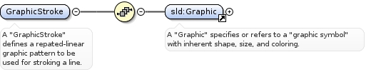
A "GraphicStroke" defines a repated-linear graphic pattern to be usedfor stroking a line.
<xsd:element name="GraphicStroke"><xsd:annotation><xsd:documentation>A "GraphicStroke" defines a repated-linear graphic pattern to be used for stroking a line.</xsd:documentation></xsd:annotation><xsd:complexType><xsd:sequence><xsd:element ref="sld:Graphic"/></xsd:sequence></xsd:complexType></xsd:element>
<xsd:element name="UserLayer"><xsd:annotation><xsd:documentation>A UserLayer allows a user-defined layer to be built from WFS and WCS data.</xsd:documentation></xsd:annotation><xsd:complexType><xsd:sequence><xsd:element ref="sld:Name" minOccurs="0"/><xsd:element ref="sld:RemoteOWS" minOccurs="0"/><xsd:element ref="sld:LayerFeatureConstraints"/><xsd:element ref="sld:UserStyle" maxOccurs="unbounded"/></xsd:sequence></xsd:complexType></xsd:element>
Element sld:RemoteOWS
Namespace
http://www.opengis.net/sld
Annotations
A RemoteOWS gives a reference to a remote WFS/WCS/other-OWS server.
<xsd:element name="RemoteOWS"><xsd:annotation><xsd:documentation>A RemoteOWS gives a reference to a remote WFS/WCS/other-OWS server.</xsd:documentation></xsd:annotation><xsd:complexType><xsd:sequence><xsd:element ref="sld:Service"/><xsd:element ref="sld:OnlineResource"/></xsd:sequence></xsd:complexType></xsd:element>
Element sld:Service
Namespace
http://www.opengis.net/sld
Annotations
A Service refers to the type of a remote OWS server.
<xsd:element name="Service"><xsd:annotation><xsd:documentation>A Service refers to the type of a remote OWS server.</xsd:documentation></xsd:annotation><xsd:simpleType><xsd:restriction base="xsd:string"><xsd:enumeration value="WFS"/><xsd:enumeration value="WCS"/></xsd:restriction></xsd:simpleType></xsd:element>
Element sld:LineSymbolizer
Namespace
http://www.opengis.net/sld
Annotations
A LineSymbolizer is used to render a "stroke" along a linear geometry.
<xsd:element name="LineSymbolizer" substitutionGroup="sld:Symbolizer"><xsd:annotation><xsd:documentation>A LineSymbolizer is used to render a "stroke" along a linear geometry.</xsd:documentation></xsd:annotation><xsd:complexType><xsd:complexContent><xsd:extension base="sld:SymbolizerType"><xsd:sequence><xsd:element ref="sld:Geometry" minOccurs="0"/><xsd:element ref="sld:Stroke" minOccurs="0"/></xsd:sequence></xsd:extension></xsd:complexContent></xsd:complexType></xsd:element>
Element sld:Geometry
Namespace
http://www.opengis.net/sld
Annotations
A Geometry gives reference to a (the) geometry property of afeature to be used for rendering.
<xsd:element name="Geometry"><xsd:annotation><xsd:documentation>A Geometry gives reference to a (the) geometry property of a feature to be used for rendering.</xsd:documentation></xsd:annotation><xsd:complexType><xsd:sequence><xsd:element ref="ogc:PropertyName"/></xsd:sequence></xsd:complexType></xsd:element>
Element sld:PolygonSymbolizer
Namespace
http://www.opengis.net/sld
Annotations
A "PolygonSymbolizer" specifies the rendering of a polygon orarea geometry, including its interior fill and border stroke.
<xsd:element name="PolygonSymbolizer" substitutionGroup="sld:Symbolizer"><xsd:annotation><xsd:documentation>A "PolygonSymbolizer" specifies the rendering of a polygon or area geometry, including its interior fill and border stroke.</xsd:documentation></xsd:annotation><xsd:complexType><xsd:complexContent><xsd:extension base="sld:SymbolizerType"><xsd:sequence><xsd:element ref="sld:Geometry" minOccurs="0"/><xsd:element ref="sld:Fill" minOccurs="0"/><xsd:element ref="sld:Stroke" minOccurs="0"/></xsd:sequence></xsd:extension></xsd:complexContent></xsd:complexType></xsd:element>
Element sld:PointSymbolizer
Namespace
http://www.opengis.net/sld
Annotations
A "PointSymbolizer" specifies the rendering of a "graphic symbol"at a point.
<xsd:element name="PointSymbolizer" substitutionGroup="sld:Symbolizer"><xsd:annotation><xsd:documentation>A "PointSymbolizer" specifies the rendering of a "graphic symbol" at a point.</xsd:documentation></xsd:annotation><xsd:complexType><xsd:complexContent><xsd:extension base="sld:SymbolizerType"><xsd:sequence><xsd:element ref="sld:Geometry" minOccurs="0"/><xsd:element ref="sld:Graphic" minOccurs="0"/></xsd:sequence></xsd:extension></xsd:complexContent></xsd:complexType></xsd:element>
Element sld:TextSymbolizer
Namespace
http://www.opengis.net/sld
Annotations
A "TextSymbolizer" is used to render text labels according tovarious graphical parameters.
<xsd:element name="TextSymbolizer" substitutionGroup="sld:Symbolizer"><xsd:annotation><xsd:documentation>A "TextSymbolizer" is used to render text labels according to various graphical parameters.</xsd:documentation></xsd:annotation><xsd:complexType><xsd:complexContent><xsd:extension base="sld:SymbolizerType"><xsd:sequence><xsd:element ref="sld:Geometry" minOccurs="0"/><xsd:element ref="sld:Label" minOccurs="0"/><xsd:element ref="sld:Font" minOccurs="0"/><xsd:element ref="sld:LabelPlacement" minOccurs="0"/><xsd:element ref="sld:Halo" minOccurs="0"/><xsd:element ref="sld:Fill" minOccurs="0"/></xsd:sequence></xsd:extension></xsd:complexContent></xsd:complexType></xsd:element>
Element sld:Label
Namespace
http://www.opengis.net/sld
Annotations
A "Label" specifies the textual content to be rendered.
<xsd:element name="Label" type="sld:ParameterValueType"><xsd:annotation><xsd:documentation>A "Label" specifies the textual content to be rendered.</xsd:documentation></xsd:annotation></xsd:element>
Element sld:Font
Namespace
http://www.opengis.net/sld
Annotations
A "Font" element specifies the text font to use. The allowedCssParameters are: "font-family", "font-style", "font-weight",and "font-size".
<xsd:element name="Font"><xsd:annotation><xsd:documentation>A "Font" element specifies the text font to use. The allowed CssParameters are: "font-family", "font-style", "font-weight", and "font-size".</xsd:documentation></xsd:annotation><xsd:complexType><xsd:sequence><xsd:element ref="sld:CssParameter" minOccurs="0" maxOccurs="unbounded"/></xsd:sequence></xsd:complexType></xsd:element>
Element sld:LabelPlacement
Namespace
http://www.opengis.net/sld
Annotations
The "LabelPlacement" specifies where and how a text label shouldbe rendered relative to a geometry. The present mechanism ispoorly aligned with CSS/SVG.
<xsd:element name="LabelPlacement"><xsd:annotation><xsd:documentation>The "LabelPlacement" specifies where and how a text label should be rendered relative to a geometry. The present mechanism is poorly aligned with CSS/SVG.</xsd:documentation></xsd:annotation><xsd:complexType><xsd:choice><xsd:element ref="sld:PointPlacement"/><xsd:element ref="sld:LinePlacement"/></xsd:choice></xsd:complexType></xsd:element>
Element sld:PointPlacement
Namespace
http://www.opengis.net/sld
Annotations
A "PointPlacement" specifies how a text label should be renderedrelative to a geometric point.
<xsd:element name="PointPlacement"><xsd:annotation><xsd:documentation>A "PointPlacement" specifies how a text label should be rendered relative to a geometric point.</xsd:documentation></xsd:annotation><xsd:complexType><xsd:sequence><xsd:element ref="sld:AnchorPoint" minOccurs="0"/><xsd:element ref="sld:Displacement" minOccurs="0"/><xsd:element ref="sld:Rotation" minOccurs="0"/></xsd:sequence></xsd:complexType></xsd:element>
Element sld:AnchorPoint
Namespace
http://www.opengis.net/sld
Annotations
An "AnchorPoint" identifies the location inside of a text label touse an an 'anchor' for positioning it relative to a point geometry.
<xsd:element name="AnchorPoint"><xsd:annotation><xsd:documentation>An "AnchorPoint" identifies the location inside of a text label to use an an 'anchor' for positioning it relative to a point geometry.</xsd:documentation></xsd:annotation><xsd:complexType><xsd:sequence><xsd:element ref="sld:AnchorPointX"/><xsd:element ref="sld:AnchorPointY"/></xsd:sequence></xsd:complexType></xsd:element>
<xsd:element name="Displacement"><xsd:annotation><xsd:documentation>A "Displacement" gives X and Y offset displacements to use for rendering a text label near a point.</xsd:documentation></xsd:annotation><xsd:complexType><xsd:sequence><xsd:element ref="sld:DisplacementX"/><xsd:element ref="sld:DisplacementY"/></xsd:sequence></xsd:complexType></xsd:element>
<xsd:element name="LinePlacement"><xsd:annotation><xsd:documentation>A "LinePlacement" specifies how a text label should be rendered relative to a linear geometry.</xsd:documentation></xsd:annotation><xsd:complexType><xsd:sequence><xsd:element ref="sld:PerpendicularOffset" minOccurs="0"/></xsd:sequence></xsd:complexType></xsd:element>
Element sld:PerpendicularOffset
Namespace
http://www.opengis.net/sld
Annotations
A "PerpendicularOffset" gives the perpendicular distance awayfrom a line to draw a label.
<xsd:element name="PerpendicularOffset" type="sld:ParameterValueType"><xsd:annotation><xsd:documentation>A "PerpendicularOffset" gives the perpendicular distance away from a line to draw a label.</xsd:documentation></xsd:annotation></xsd:element>
Element sld:Halo
Namespace
http://www.opengis.net/sld
Annotations
A "Halo" fills an extended area outside the glyphs of a renderedtext label to make the label easier to read over a background.
<xsd:element name="Halo"><xsd:annotation><xsd:documentation>A "Halo" fills an extended area outside the glyphs of a rendered text label to make the label easier to read over a background.</xsd:documentation></xsd:annotation><xsd:complexType><xsd:sequence><xsd:element ref="sld:Radius" minOccurs="0"/><xsd:element ref="sld:Fill" minOccurs="0"/></xsd:sequence></xsd:complexType></xsd:element>
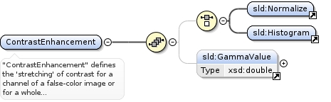
"ContrastEnhancement" defines the 'stretching' of contrast for achannel of a false-color image or for a whole grey/color image.Contrast enhancement is used to make ground features in imagesmore visible.
<xsd:element name="ContrastEnhancement"><xsd:annotation><xsd:documentation>"ContrastEnhancement" defines the 'stretching' of contrast for a channel of a false-color image or for a whole grey/color image. Contrast enhancement is used to make ground features in images more visible.</xsd:documentation></xsd:annotation><xsd:complexType><xsd:sequence><xsd:choice minOccurs="0"><xsd:element ref="sld:Normalize"/><xsd:element ref="sld:Histogram"/></xsd:choice><xsd:element ref="sld:GammaValue" minOccurs="0"/></xsd:sequence></xsd:complexType></xsd:element>
<xsd:element name="OverlapBehavior"><xsd:annotation><xsd:documentation>"OverlapBehavior" tells a system how to behave when multiple raster images in a layer overlap each other, for example with satellite-image scenes.</xsd:documentation></xsd:annotation><xsd:complexType><xsd:choice><xsd:element ref="sld:LATEST_ON_TOP"/><xsd:element ref="sld:EARLIEST_ON_TOP"/><xsd:element ref="sld:AVERAGE"/><xsd:element ref="sld:RANDOM"/></xsd:choice></xsd:complexType></xsd:element>
<xsd:element name="ColorMap"><xsd:annotation><xsd:documentation>A "ColorMap" defines either the colors of a pallet-type raster source or the mapping of numeric pixel values to colors.</xsd:documentation></xsd:annotation><xsd:complexType><xsd:choice minOccurs="0" maxOccurs="unbounded"><xsd:element ref="sld:ColorMapEntry"/></xsd:choice></xsd:complexType></xsd:element>
"ShadedRelief" specifies the application of relief shading(or "hill shading") to a DEM raster to give it somewhat of athree-dimensional effect and to make elevation changes morevisible.
<xsd:element name="ShadedRelief"><xsd:annotation><xsd:documentation>"ShadedRelief" specifies the application of relief shading (or "hill shading") to a DEM raster to give it somewhat of a three-dimensional effect and to make elevation changes more visible.</xsd:documentation></xsd:annotation><xsd:complexType><xsd:sequence><xsd:element ref="sld:BrightnessOnly" minOccurs="0"/><xsd:element ref="sld:ReliefFactor" minOccurs="0"/></xsd:sequence></xsd:complexType></xsd:element>
"ImageOutline" specifies how individual source rasters ina multi-raster set (such as a set of satellite-image scenes)should be outlined to make the individual-image locations visible.
<xsd:element name="ImageOutline"><xsd:annotation><xsd:documentation>"ImageOutline" specifies how individual source rasters in a multi-raster set (such as a set of satellite-image scenes) should be outlined to make the individual-image locations visible.</xsd:documentation></xsd:annotation><xsd:complexType><xsd:choice><xsd:element ref="sld:LineSymbolizer"/><xsd:element ref="sld:PolygonSymbolizer"/></xsd:choice></xsd:complexType></xsd:element>
Complex Type sld:ParameterValueType
Namespace
http://www.opengis.net/sld
Annotations
The "ParameterValueType" uses WFS-Filter expressions to givevalues for SLD graphic parameters. A "mixed" element-contentmodel is used with textual substitution for values.
<xsd:complexType name="ParameterValueType" mixed="true"><xsd:annotation><xsd:documentation>The "ParameterValueType" uses WFS-Filter expressions to give values for SLD graphic parameters. A "mixed" element-content model is used with textual substitution for values.</xsd:documentation></xsd:annotation><xsd:sequence minOccurs="0" maxOccurs="unbounded"><xsd:element ref="ogc:expression"/></xsd:sequence></xsd:complexType>
Complex Type sld:SymbolizerType
Namespace
http://www.opengis.net/sld
Annotations
A "SymbolizerType" is an abstract type for encoding the graphicalproperties used to portray geographic information. Concrete symboltypes are derived from this base type.
<xsd:complexType name="SymbolizerType" abstract="true"><xsd:annotation><xsd:documentation>A "SymbolizerType" is an abstract type for encoding the graphical properties used to portray geographic information. Concrete symbol types are derived from this base type.</xsd:documentation></xsd:annotation></xsd:complexType>